Skip to content

Freezing rain warning for St. Albert

icy roads CC
Freezing rain has formed in Whitecourt and Grande Prairie and is moving toward the Edmonton region, according to Environment and Climate Change Canada's forecast. File photo

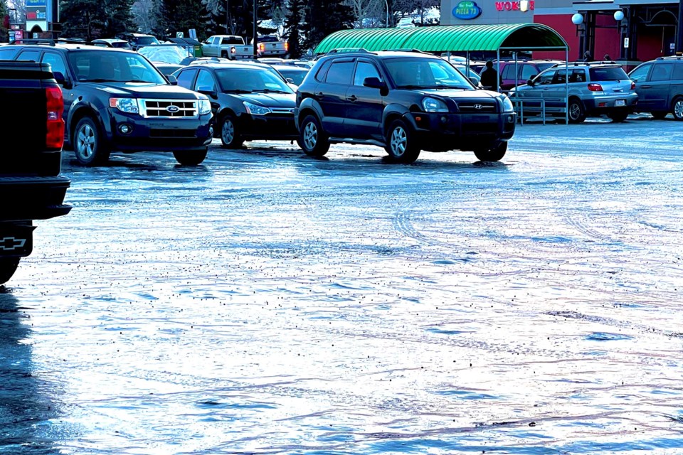
Environment Canada issued a freezing rain warning for St. Albert and area at 11:22 a.m.

"Freezing rain has developed from Grande Prairie through Whitecourt this morning," it reads. "This area of freezing rain will move toward Edmonton today."

The forecast says conditions will improve later this afternoon.

"Surfaces such as highways, roads, walkways and parking lots may become icy and slippery. Utility outages may occur."

Drive according to conditions, which means slow down. Maintain a safe following distance.

Today's temperature is expected to rise to a high of -6 C, wind chill -8. 

Ice pellets could begin falling with the snow by early afternoon and clear by dinner time.

The temperature is expected to climb back to -1 C Thursday morning, with highs in the low pluses Friday and Saturday.

Monitor alerts and forecasts issued by Environment Canada. To report severe weather, send an email to [email protected] or tweet reports using #ABStorm.

Current Weather

Chance of showers

Chance of showers

9.8°C

Pressure
101.8 falling
Dewpoint
9.2 °C
Humidity
96%
Wind
SW 2 km/h

Radar Satellite


Hourly Forecast

Today
6 AM
11°C
A mix of sun and cloud
Today
7 AM
12°C
Sunny
Today
8 AM
13°C
Sunny
Today
9 AM
14°C
Sunny
Today
10 AM
16°C
Sunny
Today
11 AM
17°C
Sunny
Today
12 PM
19°C
Sunny
Today
1 PM
20°C
Sunny
Today
2 PM
21°C
Sunny
Today
3 PM
22°C
Chance of showers. Risk of thunderstorms
Today
4 PM
22°C
Chance of showers. Risk of thunderstorms
Today
5 PM
23°C
Chance of showers. Risk of thunderstorms

7 Day Forecast

Chance of showers

Today

23 °C

A mix of sun and cloud. 30 percent chance of showers late this afternoon with risk of a thunderstorm. Fog patches dissipating early this morning. High 23. UV index 7 or high.


Chance of showers

Tonight

13 °C

A few clouds. Increasing cloudiness late this evening then 60 percent chance of showers overnight. Risk of a thunderstorm overnight. Low 13.


Chance of showers

Tuesday

23 °C

A mix of sun and cloud. 30 percent chance of showers late in the afternoon with risk of a thunderstorm. High 23. Humidex 25. UV index 7 or high.


Chance of showers

Tuesday night

13 °C

Cloudy with 60 percent chance of showers. Low 13.


Chance of showers

Wednesday

21 °C

A mix of sun and cloud with 30 percent chance of showers. High 21.


Showers

Wednesday night

13 °C

Showers. Low 13.


Showers

Thursday

16 °C

Showers. High 16.


Periods of rain

Thursday night

10 °C

Periods of rain. Low 10.


A mix of sun and cloud

Friday

19 °C

A mix of sun and cloud. High 19.


Chance of showers

Friday night

10 °C

Cloudy with 60 percent chance of showers. Low 10.


Chance of showers

Saturday

14 °C

Cloudy with 60 percent chance of showers. High 14.


Cloudy periods

Saturday night

6 °C

Cloudy periods. Low 6.


A mix of sun and cloud

Sunday

17 °C

A mix of sun and cloud. High 17.


Normals

Low
10 °C
High
21 °C

Sunrise and Sunset

Sunrise
5:04 AM
Sunset
10:05 PM

Based on Environment Canada data

push icon
Be the first to read breaking stories. Enable push notifications on your device. Disable anytime.
No thanks