
A new road could mean a shortcut into Edmonton from the Sturgeon Valley, say county residents, but could also mean more dead deer near Riverlot 56.
County residents got their first look last week at the proposed routes for the realignment of 127 Street. The road, which currently dead-ends north of Edmonton, is supposed to hook into the Anthony Henday and connect to Highway 2 north of St. Albert at some point in the future.
This particular road has been on the province's books for years, but has never had a specific route. Sturgeon County is now hammering out that route in order to convince the Capital Region Board to approve the Sturgeon Heights subdivision.
About 140 people crammed into the Sturgeon Valley Golf and Country Club on Oct. 5 for an open house on the road — about 40 of them there before the event officially started.
Two routes presented
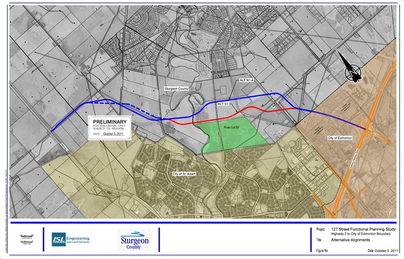
The road, if built, would be a four-lane divided arterial roadway with a speed limit of 70 kilometres an hour, according to Hassan Shaheen, project manager with ISL Engineering and Land Services.
"It's a relatively lightly travelled urban road," he said, but in the future could handle up to 12,000 cars a day, equivalent to a third of the traffic on St. Albert Trail during rush hour.
Council will have to choose between two alignments, he continued, both of which could be combined or modified based on comments from residents.
"Technically, they're very similar," he said, and should cost about the same. "The difference is primarily at and south of the Sturgeon River."
Both routes are about the same length, Shaheen said, and start at the Edmonton border and end at Township Road 544 leading to Hwy. 2. Both will pass under a rail line (as going over would make it too steep) and over the Sturgeon River, and will likely have traffic lights where they cross other roads.
The southern route, coloured red on the conceptual maps, cuts along the northeast edge of Riverlot 56 and through a forest north of Edmonton. It's also about $2 million more than the other, as it runs under a curved part of a railroad track.
The northern route, coloured blue, veers further east of the river lot but separates it from an oxbow in the Sturgeon. It cuts under a straight part of the aforementioned train track, making it cheaper.
Noise and deer
Jan Dekker, who has lived in the region since 1979, said he was worried about how the road would affect the animals around the riverlot.
"You get a four-lane highway there, and a lot of deer will be hit."
Adding an overpass over Sturgeon Road (another hot-spot for road-kill) could make the road safer for animals, he suggested.
Neither of the routes would have a direct impact on the riverlot, said Lynn Maslen, who studied the road's environmental impact for Spencer Environmental Management Services Ltd., as they would not cross its borders. She did not look at indirect impacts such as animal migration routes.
Holly Parker, Dekker's neighbour, was concerned about noise.
"This is going to become the main road for all the semis coming down Highway 2 south that want to go east," she said. "The noise level is just going to go [up] and it's going to be 24 hours."
Resident Vickie Strenbitsky and her sister Irene Garrick said they were looking forward to the road because it would give them a quicker route into Edmonton.
"We don't want to go all the way to St. Albert to get to Edmonton," Strenbitsky said.
Council is expected to pick one of the two routes at its Oct. 25 meeting, Shaheen said, and would present its choice at an open house in January. Plans for the road should be complete by April, with the road itself built sometime afterwards.
Any questions should go to Jenny Burgess at 780-438-9000.


