
The City of St. Albert has won a national award for creating a high-tech map to help manage disasters.
The City of St. Albert received an Emergency Management Exemplary Service Award from Public Safety Canada at a ceremony in Ottawa on Feb. 26. The award is a partnership between Canada’s federal, provincial, and territorial governments, and recognizes excellence in the various fields of emergency management.
The City of St. Albert was one of the 16 winners in the resilient communities category. Named recipients were Brian Carabine, Alice Cerqueira, Denise Isbister, Shawn Kirkpatrick, Marci Ng, Cara Parenteau, and Kendra Verheul of the city’s incident management team, which is overseen by city emergency management manager Mark Pickford.
Emergency tools
Pickford said he nominated St. Albert for this award based on a series of tools he asked the incident response team to create — tools his many years on the front line of natural disasters with the military taught him would be a huge help during an emergency.
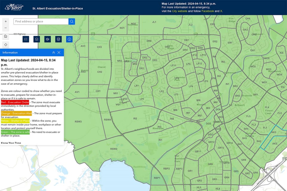
The first tool was the Know Your Zone project.
If a train derails and the city needs to evacuate everyone within a one-kilometre radius of it, it can be tough for people on the ground to know if they’re inside or outside that invisible circle, Pickford said. St. Albert also has some really big neighbourhoods, and it can be challenging to spell out what specific chunks of them are at risk using just street names and directions.
Know Your Zone uses ArcGIS mapping technology to create what is currently the only interactive evacuation/shelter-in-place map in Alberta. The map divides St. Albert into zones based on traffic flow so evacuees can get out without blocking emergency crews from getting in. Each zone is colour-coded to indicate if people should evacuate (red), prepare to evacuate (orange), shelter in place (yellow), or behave as normal (green) at any given time. The map is paired with census data so crews know the demographics of affected zones — handy when crews need to know how many emergency shelters to create, for example. The city put out flyers and online posts to teach residents about the map and what zone they are in.
The second tool was a rapid damage assessment system.
Fires and tornadoes often damage or destroy some homes while leaving others untouched, Pickford said, citing the recent Jasper wildfire as an example.
“There’s a lot of political pressure to know what’s destroyed and what’s not destroyed,” he said, and a practical need for crews to know which parts of town can be safely powered on.
Pickford said the damage assessment tool lets responders walk down a street during a disaster and take pictures that get put on a map in real time, allowing residents to see if their homes are still standing and responders to know where they can safely restore gas, water, and power flows.
Pickford said the team also brought in the Everbridge Mass Notification System to let responders communicate with and locate every staff member during an emergency. Crews used this system during last December’s emergency simulation to tell participants to shelter in place and to ignore any fire alarms (one of which was triggered as part of the exercise).
Pickford said this award (a plate-sized green medallion with an elaborate gold crest on it) recognizes the hard work of all City of St. Albert employees.
“It’s a demonstration that St. Albert is getting better prepared than [it was] yesterday.”
Visit bit.ly/4h1UO9v for more on the award.


