
One of the cheapest possible fixes for the Big Lake viewing platform could be off the table because of the AltaLink power line that runs overhead, say city officials.
About 90 people checked out the proposed Red Willow Park West master plan and possible fixes for the Big Lake Environment Support Society (BLESS) viewing platform held Wednesday at the Kinsmen Club. It was the second open house held this year on both subjects.
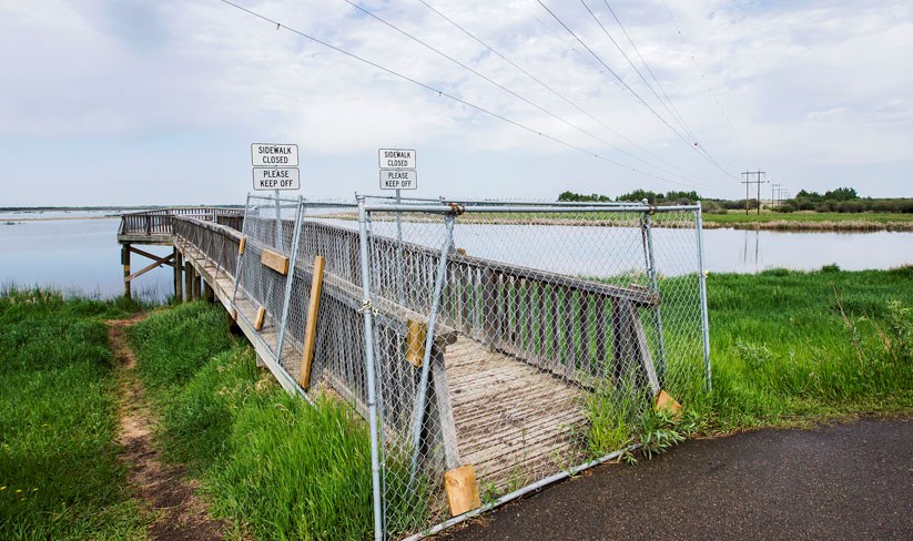
City councillors have debated since December whether or not to fix, replace, or destroy the BLESS viewing platform on Big Lake, which was closed last summer due to structural problems.
Residents were asked to look at six options Wednesday, two of which were new and one of which had changed.
The cheapest option was to destroy and not replace the platform, which could be done by next March for $110,000, said city capital projects manager Meredith Willacy. Engineers could repair the platform by March and have it last five years for $180,000, or spend $341,000 to fix it for 10 years, which couldn’t be done before 2020.
New are two proposals to demolish the platform and replace it with a boardwalk that would stick out from the current asphalt bike trail without jutting over the water. One was a 3.5 by 15 metre rectangle, while the other was a roughly 3.5 by 10 m L-shape with an on-ramp. The rectangle would be parallel to the Sturgeon River, while the L would point in the same direction as the current platform. Both would be about half the size of the current platform and would require expensive screw-piles for stability.
These options would each cost about $280,000, Willacy said – $170,000 to build, plus $110,000 to demolish the old platform, which would be a safety hazard if left standing. The new boardwalk would be ready to use by January 2020.
While the platform was originally built in 1996 for about $12,500, that was done using donated materials and labour and not to today’s standards, said Willacy, when asked about these costs. Today’s building codes and environmental standards make fixing it much more expensive.
While some residents had called for a $140,000 solution that would simply lop the end off the current platform to bring it out of the water, Willacy said that option was temporarily off the table because of the AltaLink power line overhead.
AltaLink’s policies don’t allow structures that encourage people to congregate within a power line’s right of way, Willacy said. The current platform is okay, because the octagonal “congregating” bit is just outside the right of way, but if you chop off that bit, the end of the platform would then be underneath the lines.
“The current direction they’re telling me is that it’s not viable,” Willacy said of this option, but the city was in talks with both parties on a compromise.
Dave Burkhart of BLESS said he was confident that this option was still viable, as AltaLink personnel he’d spoken with said that the company had previously approved parking lots and community gardens underneath their lines.
“That could be an option that could be resurrected.”
Burkhart said he preferred the L-shaped boardwalk to the rectangular one, as the rectangle didn’t face the lake and didn’t add much to the region. He was concerned, though, that the city had proposed to leave the pilings for the old platform in place with both options.
“That’s going to be an eyesore,” he said, and would ruin every photograph of the sunset out there.
Willacy said administration was also studying a proposal to replace the platform with some sort of floating structure.
Details on all six options are available at stalbert.ca/rec/parks/system/big-lake. Information from the open house on the BLESS platform will be presented at the July 9 council meeting.
Trail plans tweaked
Visitors at the open house Wednesday also got to comment on master plans for Red Willow Park West and Riverside, both of which involve the lands in and around the Grey Nuns White Spruce Park.In response to comments received at the last open house, planners have moved all the proposed bike trails in the Red Willow Park West region away from the banks of Big Lake and the Sturgeon River to better protect riparian zones, said city parks planning specialist Margo Brenneis. The plan proposes standard asphalt bike paths around the white spruce forest and a limited network of smaller gravel paths inside it, as well as a picnic and nature playground area in the open part of the forest.
City resident Ken Crutchfield said he appreciated how the city pulled the trails back from sensitive riparian zones, but was concerned about the number of trails proposed, as the city was already having troubles maintaining its current network. He also questioned the use of gravel trails in the white spruce forest, as compacted gravel could harm tree roots.
“Why not have wood mulch trails for those natural trails?” he asked.
The Red Willow Park West plan also sketches in trails along Carrot Creek. These trails were years away from development (as no one’s building in this area yet), but do include a possible off-leash dog park near Ray Gibbon and Meadowview Drive, Brenneis said.
The Riverside plan identified seven potential park spaces in the Riverside neighbourhood adjacent to the white spruce forest and potential features of each, Brenneis said. Depending on their size and shape, the parks could be anything from simple treed open spaces to full-fledged sports fields.
Brenneis said her team would tweak these park plans and come back with costs and a timeline by the end of the year.
The plans and an online survey about them can be found at bit.ly/2sFvUXD.


