
After more than two years of discussion, debate, public engagement, conceptual designs, and more public engagement, a draft of the St. Albert West Area Structure Plan (ASP) was published by the city last week.
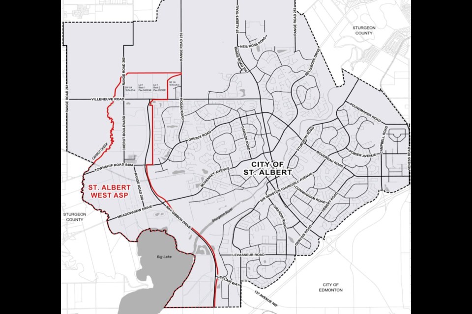
ASPs are legally required planning documents that determine how a certain area will be developed. The St. Albert West ASP has an eastern border of Ray Gibbon Drive, a southern border of 137 Avenue, a western border of Big Lake and Carrot Creek, and a northern border that extends about half a kilometre north of Villeneuve Road.
In all, the West ASP covers 1,035 hectares of land, including the land designated to be the long-talked about Lakeview Business District; a potential recreational centre; and the city's Badger Lands, which were once planned to be home to the city's solar farm.
Council last received an update on the ASP's development in December, and little has changed in terms of the land use plan, goals, or guiding development principles since.
City planner Tracy Tsui said the only change that needed to be made to the ASP in the past few months was to redraw the southern portion of the area map to reflect the provincial government's decision in January to add 238 hectares of land to Lois Hole Centennial Provincial Park.
A chunk of the newly protected parkland, specifically the parking area accessible only via LeClair Way, was previously covered within existing West ASP land maps and needed to be removed, Tsui said.
“We spent a lot of time working on the technical side of this during the time [since December],” she said, referring to how many of the ASP's supporting studies, such as a Transportation Impact Assessment and a Natural Features Assessment, were recently completed and published online for the public to see.
“Those are all now shared to support the land use concept.”
The new draft states that the ASP's land use concept will “enable strategic and sustainable economic growth that enhances St. Albert's competitiveness and attractiveness to investors and employers within and beyond the Edmonton metropolitan region.”
The ASP will also create an estimated 5,000 jobs, the draft says, and it will push the city towards its desired goal of having a 70/30 residential and non-residential property tax split, rather than the 80/20 tax split that the city has had, or has been close to having, over the past few years.
Helping the city achieve the council-set goal of a 70/30 tax split will be the roughly 300 hectares of commercial and employment area development called the Lakeview Business District. Most of this employment area is designated to be between Meadowview Drive and the Canadian National Railway line, while additional employment area development is slated for the land north of Villeneuve Drive up to the ASP's northern border.
“While the ASP provides for various types of development... an important focus of St. Albert West are the employment areas generally located [west of Ray Gibbon Drive and south of Villeneuve Road],” the draft reads. “This enhanced focus on employment areas supports the goals of [St. Albert's municipal development plan] Flourish by expanding St. Albert's non-residential land base and providing employment opportunities.”
The draft also states that about 250 hectares of land will be kept as environmental reserve land, meaning development won't take place on it; 120 acres will be used to build and expand roads; residential neighbourhoods will cover 83 hectares of land; 42 acres will be used as stormwater management facilities; and the future recreation centre is planned to cover 22 hectares.
Tony Druett, a director of the Big Lake Environmental Support Society (BLESS), said he was feeling hopeful that no commercial or employment-focused development will take place immediately south of Meadowview Drive, which has been a major concern for BLESS throughout the ASP's development out of concern for the health of Big Lake.
“It's more and more unlikely that there will actually be industrial parcels [south of Meadowview Drive],” Druett said.
“If we could get a commitment from somebody [with the city] that they don't intend to build industrial parcels here, we would probably support this plan.”
Druett said the fact that Meadowview Drive has been labelled a crosstown roadway, which under St. Albert's roadway classifications means a road with a speed limit of 60 kilometres per hour that serves as an east-west corridor, likely means any development near Meadowview Drive won't be built facing the road.
“This means that it won't be like Riel Drive, it will be more like Sir Winston Churchill Avenue or Boudreau Road and Giroux Road where there isn't anything fronting onto it,” he said. “It almost rules out the possibility of there being isolated [industrial] parcels on the south side [of Meadowview Drive] fronting onto it.”
He added that other reasons he's hopeful is because the ASP's land use map shows two stormwater management ponds on the land south of Meadowview Drive, and because other maps included in the draft show that, for now, the city's plans to service the area don't include any plans to bring wastewater or water servicing infrastructure to the south side of Meadowview Drive.
Council is scheduled to give first reading to the draft on June 4, after which it will be sent to the Edmonton Metropolitan Region Board (EMRB) for endorsement, and then a public hearing will occur in early September before council completes second and third readings.
The draft and all studies and reports associated with the ASP can be accessed through the city's Cultivate the Conversation platform.


