
St. Albert has a new development plan for the west side of the city, an area that includes the proposed Lakeview industrial district.
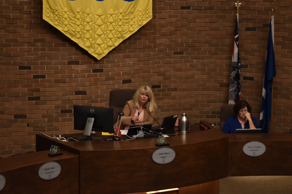
City councillors voted 6-1 to pass the the St. Albert West Area Structure Plan (ASP) through second and third readings at their first regular meeting of the fall on Sept. 3.
Only Coun. Mike Killick, who has concerns over how close developers will be able to build near sensitive environmental areas, voted against.
There are “significant” no-build riparian zones of between 100 and almost 600 metres from the shores of Big Lake, and 50 m from the banks of Carrot Creek, for example. But language in the ASP that allows developers to apply for permission to build closer to water has Killick worried.
“I’m still concerned with saying with we have 50 m of top-of-bank setback on Carrot Creek but hearing in the same conversation that neighbourhood (development) plans can significantly chip into that and get it down to 20 m,” Killick said.
“So, I have a real problem approving something here that says 50 m: I can’t imagine any builder would not apply to reduce that to the bare minimum they can get away with. I don’t know why they would stick to the 50 m. This bylaw hasn’t even passed yet and one of the landowners is asking to reduce it in advance down to 15 m.”
In a written submission, Sean Novak of ISL Engineering and Land Services requested that the city use setback values from a study conducted by J.R. Paine & Associates Ltd. for the proposed Avenir North Subdivision earlier this year.
That document “identifies a recommended Urban Development Setback Line (UDL) and Building Setback Line (BSL) that are 15 metres from the top-of-bank line (this includes a 5-metre erosion setback),” Novak wrote. “The analysis also identifies a recommended Water Feature Setback Line to normal water level that is 25 metres from the top-of-bank line. Given that the required technical study has been completed using site specific field data, the West ASP should reflect the findings of this technical work instead of deferring refinement to the Neighbourhood Plan stage.”
That stage could be years or decades away. Killick said when that day comes, the memory of Tuesday’s meeting will have faded. He called it his “pave over paradise fear.
“I would be prepared to bring forward a motion that in some way says ‘we have to protect that environment’ rather than still showing it as designated as open to industrial development.”
In contrast, Coun. Wes Brodhead said he was happy with the balance struck.
Setting the setbacks from riverbanks is “all about working together to find the best way to meet the needs of the environment so we have trails and amenities (for residents), but also a pathway for the environment to move through our community.”
As Coun. Ken MacKay pointed out, the ASP regulates 2,557 acres or 1,035 hectares of land, an area envisioned to include land uses as many as they are varied, from residential neighbourhoods to light industrial parks and commercial spaces, not to mention an existing provincial park, all coexisting with a “significant wildlife corridor.”
“This is a very important ASP,” Coun. Sheena Hughes said. “The amount of sensitivity to manage so many balls in the air and end up with a design that is achievable – I think you did that in spades. This is our development in many ways and this was well done.”
Mayor Cathy Heron told the city staffers present she has put her “complete trust” in them to do a good job of managing the development of land in the West ASP.
The ASP in a nutshell
The St. Albert West Area Structure Plan (ASP) would apply to an area bordered by the city boundary on the west and south; Ray Gibbon Drive, predominantly, on the east; and a line half a kilometre north of Villeneuve Road on the north.
Affecting 1,035 hectares, it would swallow the entire Cherot and North Ridge Phase 2 ASPs, and includes the land designated for the Lakeview Business District, a potential recreational centre, and the city's former solar farm destination, the Badger Lands.
About 600 hectares are considered developable. The city is required to protect almost 300 hectares that fall under the Environmental Reserve designation (flood lines around Carrot Creek). A protected area surrounding Lois Hole Centennial Provincial Park and the Ray Gibbon Drive right-of-way take up an additional 132 hectares.
The ASP estimates development in the area will create 5,000 jobs and will push the city toward its desired goal of having a 70/30 residential and non-residential property tax split. Currently, that burden is closer to 80/20.


