
A restored Carrot Creek could help channel runoff from about 100,000 residents towards Big Lake, suggests a joint infrastructure plan between the city and the county.
The St. Albert-Sturgeon County inter-municipal affairs committee received a summary of the joint infrastructure review report Wednesday.
The report, which is still in the works, sets out how the city and the county should best lay out road, water, stormwater and sewage networks along their shared borders over the next 80 years.
The city and the county risk under-sizing needed infrastructure if they don't plan this region together, said St. Albert Mayor Nolan Crouse. Given that places like Carrot Creek fall exactly on their shared border, it makes sense to manage them co-operatively.
The two governments recognize that there may be a better way to plan this place, said county Mayor Tom Flynn.
"What's the right way to service this area if there were no borders between us?"
The committee used a $150,000 provincial grant to have consultant Urban Systems create a joint infrastructure review of the border region.
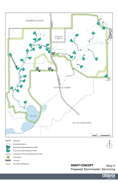
The study covers the north, west, and northeast sides of St. Albert, including Carrot Creek and parts of the Sturgeon River valley, said Golnaz Azini, project leader with Urban Systems. It assumes that the region becomes fully developed with 100,000 residents, which the Capital Region Board projects should happen in 80 years or so.
"The area is quite massive," Azini said in an interview, covering some 7,000 hectares. The study lays out roads, pump stations and sewer lines in this area based on topographical considerations without regard for municipal boundaries.
Water, water everywhere
The study predicts that three new reservoirs plus the soon-to-be-expanded Allin Ridge reservoir will be needed to service this area in 80 years. It will also need about six new sewage lift stations.
It also envisions some 32 new stormwater ponds to control flows into Carrot Creek and the Sturgeon River. That sounds like a lot, but most developments have at least one pond for every 64 hectares of land, Azini said.
"Carrot Creek was identified as a sensitive environmental feature," Azini said, and her team was asked to figure out how to manage flow rates to it.
Although past planners had envisioned collecting runoff in two big pipes on either side of the creek, Azini's team found that this was the most costly option, as you'd have to build the pipes all at once well in advance of development.
"The creek would no longer be a creek after you pipe all the water," she noted.
"It's not a thinking-ahead kind of approach."
Azini's team recommended that the city and county instead enhance the riparian zone around the creek, using native plants and stormwater ponds to control flow rates and erosion. This was the cheapest option and the one best suited to deal with wild weather caused by climate change.
Public transit and trail systems are a must for this region, Azini told the committee.
"With the addition of 100,000 people, it cannot be serviced just by vehicles."
The plan proposes an LRT line to this region as well as a commuter bus to Morinville. It also recommends that all roads have multi-use trails and sidewalks.
The report suggests that the city and county create a regional commission, non-profit, controlled corporation or a partnership to manage this joint infrastructure.
This is a broad, conceptual plan that's not meant to show exactly what goes where, Azini said in an interview. Still, it shows how the city and the county could share infrastructure to save money.
County commissioner Peter Tarnawsky said that while the finished report won't in itself have any legal force, it should help guide future city and county plans.
Azini said the finished study, complete with cost estimates, should be available to both councils in a couple of months.
Parallel effort
The committee also heard from a group of developers who was also working on a joint servicing plan for the lands northeast of St. Albert.
Art Valerio, of Four Corners Projects, told the committee that his company teamed up with Landrex, Triple 5, Melcor and Cameron Communities earlier this month to create the St. Albert-Sturgeon Service Solutions Group (4SG). This group had agreed to work together to plan and pay for water and sewer servicing amongst their lands on the north side of St. Albert.
"We got together in the spirit of them getting together and co-operating," Valerio said in an interview, referring to the city and county governments.
"What they're doing is outstanding."
Initial work by consultant Al-Terra Engineering suggests that it will cost about $16 million to service their combined properties, said Valerio, chair of 4SG. He hoped the Urban Systems study would complement the Al-Terra study, which was still in the planning stages.
Communities can save money, plan farther ahead and service more people when they work together, Valerio said.
"They can create the borders on their communities that they want."


