
Like many other Edmontonians, Ben Arril moved to the city with memories of a different place called home.
So when it came to filling the empty walls inside his apartment, he thought up a creation that would fire both his professional passion, and let him remember the places he’s been.
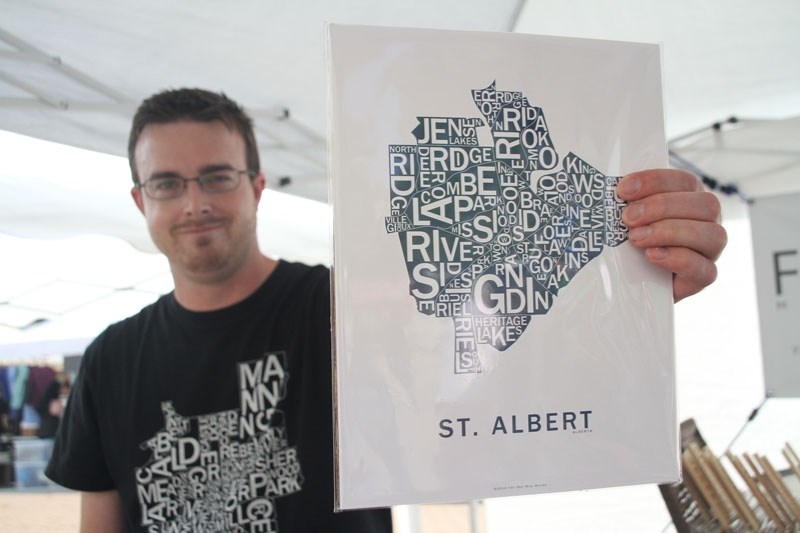
The professional cartographer now uses his spare time to create Far Sky Map Works, colourful, typographic maps that depict the geographic borders and names of Canadian provinces and cities.
And even though they created quite a following later on, he recalls that when he first proposed to hang maps on their walls, his wife said, “No.”
“So I created the Victoria and Edmonton map and Victoria is where we met and fell in love and that’s where I went to school and she loved it,” he says.
“I put up Victoria and Edmonton side by side sort of as a theme of where we are from and where we are going … and next thing I knew I had all of our friends (come over) and they loved it.”
Arril has since expanded his collection to one map of every province (except Nunavut, which he says he’s never visited), a Canadian map, some city maps, and one of Westeros – a continent in the popular HBO show Game of Thrones.
The maps are sold online and, since 2013, at markets in the region, including the St. Albert Farmers’ Market.
“The first time someone picked up one of my maps I was wondering what they were going to say,” he says.
“So this woman came and she picked it up and she looked at it and she paused and says ‘This is amazing.’ And she pointed at it and says ‘This is where we sat on the beach and this is where I met my husband.’”
“That’s why I made these maps. Because they spark this story of a happy memory.”
He added that each map takes about two months to make.
He uses different computer programs to create them and size the letters inside the borders, he says. But he also takes a lot of time studying provincial and federal boundaries and satellite photography and tailoring the maps to them.
As a cartographer, it’s important to him to make the maps as accurately as possible, he says. Otherwise people may call him out on it, he laughs.
But map making and the arts also run in Arril’s genes.
His family history includes his grandfather C.W. Jefferys, an artist who was instrumental in the creation of Canada’s Group of Seven, and Thomas Jefferys, geographer to King George III in the 1700s.
Today, Arril continues some of these traditions, though he’s not much of an artist, he says.
“I’m a horrible artist but I make wicked maps,” he laughs, adding that he would also never claim to have invented typographic maps.
“I’ve seen a lot of similar stuff before. Typographic maps is nothing really new and I really just wanted to put my own style into it.”
Far Sky maps come in two sizes, costing $15 or $30 each. Arril says he picks the sizes to fit into common frames (he buys his at IKEA), and tries to keep them as affordable as possible.
All of his maps are printed by local companies. Those with brown paper are made from recycled materials and were printed on a 135-year-old printing press to give them ‘a more vintage look’, he says.
For more information go to farskymapworks.com or visit him at the St. Albert Farmers’ Market on Saturdays.


